
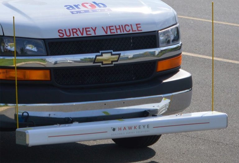
ROAD SURVEY EQUIPMENT
Hawkeye 1000 Laser Profiler Kuwait
Hawkeye 1000 Laser Profiler Kuwait is a World Bank Class 1 digital two-laser profiler from Burgan Equipment Co. for measuring longitudinal profile, roughness and macrotexture at highway speeds. Developed by ARRB Systems, it uses precision laser sensors sampling 32,000 times a second, with low-noise accelerometers that compensate for vehicle body movement. Its portable, detachable beam mounts on the front or rear of most vehicles, while an accurate Distance Measuring Instrument (DMI) and GPS link every reading to distance and position. Burgan supplies the Hawkeye 1000 in Kuwait, with installation, training and local support.
Key system highlights
- Hawkeye 1000 Laser Profiler Kuwait: World Bank Class 1 road profiling with two precision lasers.
- Highway-speed surveys: measures at traffic speed, reducing survey time and cost.
- Three measurements in one pass: longitudinal profile, roughness (IRI) and macrotexture (MPD and SMTD).
- High-speed lasers: digital sensors sampling 32,000 times per second.
- Vehicle-independent results: accelerometers compensate for body movement on any vehicle.
- Easy installation: fits without special tools or technical personnel.
- Detachable beam: lightweight aluminium beam in weatherproof housing, front or rear mounted and easily shipped.
- Location-linked data: every reading tied to chainage and GPS coordinates.
- Simple turnkey operation: one application controls the whole survey.
- Arabic and English software: multi-language acquisition and analysis suite.
- Expandable: add up to two HD cameras, DGPS and Gipsi-Trac road geometry.
- Processing software included: Hawkeye Processing Toolkit for analysis and reporting.
Technical Specifications
- Model: Hawkeye 1000 Laser Profiler Kuwait package, HKE-1000-2L-0C (two-laser configuration).
- Longitudinal Profile Accuracy: ±0.5 mm.
- Profile Wavelengths: 100 mm to 100 m.
- Laser Type: Digital, 32 kHz (32,000 samples per second).
- Laser Position: Wheel paths, typically 1.5 m apart, or as specified.
- Macrotexture: SMTD (5 mm) and MPD (1 mm).
- Profile Sampling Rate: IRI 25 mm; texture 1 mm.
- IRI Resolution: 0.01 IRI.
- Beam Width: 1.682 m (two lasers).
- Beam Material: Anodised aluminium.
- Survey Speed: 1–115 km/h. Roughness accuracy may be affected below 20 km/h, and a low-speed IRI algorithm is included.
- Distance Measurement: Wheel-mounted DMI sensor.
- GPS Accuracy: 5–15 m.
What’s in the package
- 2 × precision lasers with mounting beam
- 1 × Distance Measuring Instrument (DMI)
- 1 × GPS receiver (5–15 m accuracy)
- 1 × Hawkeye software suite
- 1 × laptop
Available outputs
- Longitudinal profile: CSV, ERD and PPF formats
- Roughness: IRI, NAASRA, Ride Number and HATI
- Macrotexture: MPD and SMTD
- Advanced wavelength filtering
- GPS location and distance
Onlooker Live (acquisition)
- Real-time control of all Hawkeye inputs from one application
- Runs on a laptop with a fully customisable screen layout
- Live display of profile, speed, distance and GPS maps
- Navigation tools, reference points and event recording
- Spoken system warnings for the operator
Processing Toolkit (analysis)
- Calculates IRI, MPD/SMTD and longitudinal profile
- Extensive analysis and batch reporting
- Mapping interface with Google background maps
- Exports to CSV, PDF, Word, Excel, KML and SHP
- Advanced HDM-4 export, compatible with most PMS and GIS tools
- Windows 64-bit compatible
Standards
- ASTM E950: Class 1, longitudinal profile
- World Bank TP 46: Class 1
- AASHTO PP37: pavement roughness
- EN 13036-6: Class 1
- ASTM E1845: macrotexture (MPD)
- TRL Lab Report 639: SMTD
- ISO 13473: Mean Profile Depth
- AUSTROADS: guidelines, where applicable
Applications
- Pavement condition assessment: network-level roughness and texture surveys.
- Paving quality assessment: accurate ride-quality checks on new surfaces.
- Quality control and dilapidation surveys: before-and-after road condition records.
- Contract validation: objective acceptance data for road projects.
Frequently Asked Questions
The Hawkeye 1000 is a World Bank Class 1 laser profiler that measures longitudinal profile, IRI and macrotexture at highway speeds. The Roughometer III is a World Bank Class 3 device that measures roughness (IRI) only, using an axle-mounted accelerometer. Choose the Hawkeye for detailed, high-accuracy surveys and the Roughometer for cost-effective roughness monitoring.
Class 1 is the highest accuracy level for road profiling devices. It means the profiler measures the true road profile precisely enough for project acceptance and research-grade surveys.
Macrotexture is the coarse texture of the road surface, reported as MPD or SMTD. It affects skid resistance, water drainage and tyre noise, making it important for road safety assessments.
Yes. Burgan Equipment Co. supplies the Hawkeye 1000 Laser Profiler Kuwait road authorities and consultants rely on, with installation, operator training and local support.
Related Products
Roughometer III Road Roughness Meter
World Bank Class 3 road roughness meter with GPS. True IRI output with no periodic calibration.
Explore Our Road & Pavement Testing Range
From road roughness and pavement profiling to deflection and density testing, Burgan Equipment Co. supplies a complete range of road pavement testing equipment in Kuwait, backed by installation, training and local after-sales support.